Showing posts with label East India Company Army. Show all posts

Sunday, 16 April 2017

Lt. Col McDowell's Campaign in the Khandesh


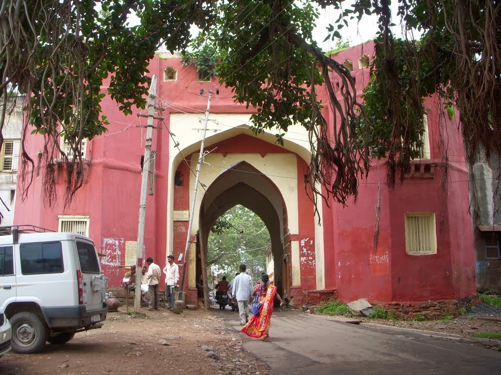
Figure 1: Unke or Ankai Killa, 
please click on this image for larger version. 
Photo courtesy of Vivek Pillay

Following the breaking up of the Army of the Deckan, the Hyderabad Subsidiary Force, that had formerly been the Second Division or Hydrabad Division under Brigadier-General Doveton, was tasked with pursuing the Peishwah towards Nagpoor.

A detachment commanded by Lieutenant-Colonel Andrew McDowell, was however was sent at the request of Mountstuart Elpinstone to the Khandesh in order to reduce the fortresses and walled towns, that were being occupied by the defeated Arab mercenaries released from Holkar’s army defeated at Nagpoor, who had been allowed to make their way towards the western coast, but who were roaming the Kandeish attempting to live off the land, in the absence of any of the back pay they were owed by their former employer. Lt. Col. McDowall’s detachment consisted of the following units.

2 Flank Companies[1] of His Majesty’s Royals.
3 Companies of the Madras European Regiment.
The 1st Batt. 2d Regiment Madras Native Infantry.
4 Companies of the 2d Batt. 13th Regt. Native Infantry.
Sappers and Miners 80 men.
1 Company of foot-artillery. [2]

 A small battering train consisting of two 18 pounders, two 12 pounders, two mortars, four howitzers and some field pieces, was attached that had been collected from those of the first, second and third Divisions of the Army of the Deccan. [3]

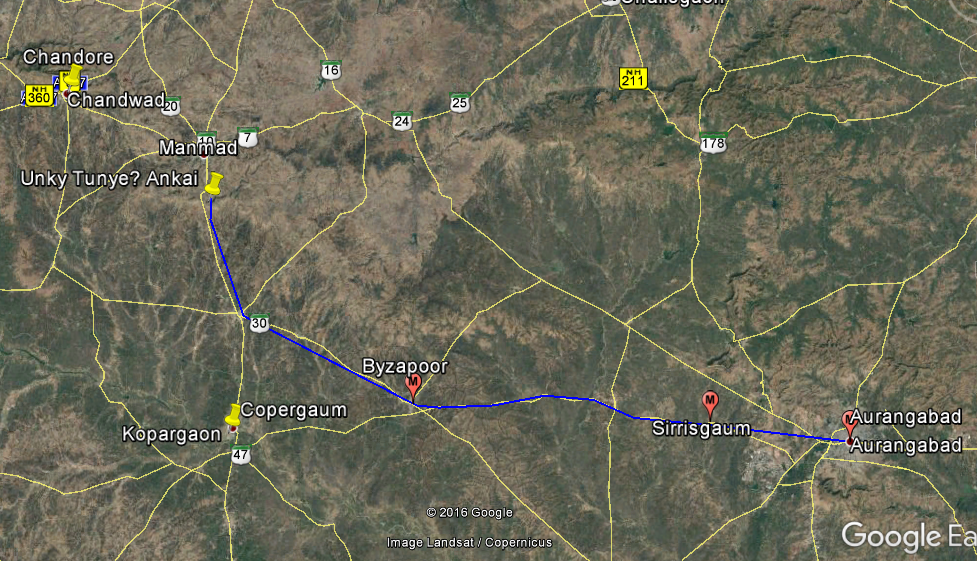
McDowell only had about 1000 firelocks in total in his column, when he had left Sirrisgaum [4] near Aurungabad [5]  on the 30th of March 1818.

His force marched first to the west to Byzapoor [6] arriving on the 2nd of April, before turning towards the north towards its first target, Unkye Killa [7] which is a table-mountain overlooking an important pass about 70 miles from Aurungabad. The fort contained a small garrison, and Lt Col McDowell summoned it, as he approached the Pettah [8]  at the fort of the hill, to form his camp.


Figure 2: Google Earth Image marked to show the route taken by McDowell's column

Lieutenant Edward Lake describes the type of fort that McDowell's forces was about to attack.

“The reader must imagine a series of hills, rising very abruptly from 600 to 1100 feet above General the plain, and only connected with each other, and with the range of which they form part, by very low and narrow necks of land; and he must further imagine occasional bluff rocks, perfectly perpendicular, and varying in height from 80 to 100 feet, to rise from the summit of these hills. The range is evidently primitive, and the rocks which rise from them in this manner, basaltic, being so beautifully and regularly scarped, as to assume the appearance of having been formed by the chisel: and the number of them scattered throughout this range, which is much greater than could be required for the defence of the country, is the only fact, which makes the supposition of their having been formed by art incredible; for the excavation of the ditches at Dowlatabad, out of the same species of granite rock, is a proof of what difficulties the perseverance of the Natives of India is capable of surmounting. Those hills, which contain water on their summit, have been fortified by the Natives, in periods of the most remote antiquity, for there is no record of their first occupation; and the space contained within the rocky scarp before described, which often assumes a very fantastic form, such as only could have been traced by nature, constitutes the interior of the Fort. There is seldom any work raised on them, or indeed any thing done, farther than to cut flights of steps out of the solid rock, and to construct a number of gateways over them; and great ingenuity has been exerted to render these as intricate as possible. Nothing is necessary, but a determined Garrison to render such positions perfectly impregnable. Fortunately for us, this latter requisite was wanting, Unkye and Unkye Tunkye set an example, which was surrenders generally followed, of surrendering without opposition, the Killedar being intimidated by the determined language held out to him.” [9]


Figure 3: Aerial View of Unkye, part of the Inyadree Range.

“He arrived, on the 2d of April, at Byzapoor, on his route towards Unkye, a hill-fort on the summit of the Khandesh Ghats. It contained a small garrison, and commanded one of the principal passes descending into the low country. On this account it was considered of peculiar importance; and Lieutenant-colonel Mac Dowell summoned it, as he approached the pettah at the foot of the hill, to form his encampment. Some attempts at evasion from the garrison were met by a display of impatient determination; and the British troops proceeded to occupy the place on one side, as it was evacuated on the other. This proof of the impression which prevailed in the country, was highly satisfactory. Filled as it was with hill-forts, an opposition from all, however trifling, would have required larger means than those by which it could be met. The minds of the inhabitants also would have remained in a state of suspense, the prevention of which was very desirable. A party of forty Native infantry, under a European officer, was left in the place, wherein were found fourteen pieces of ordnance, with a large store of ammunition, and some treasure. The detachment halted till the 7th, and, on the three following days, marched to Chandoor, where it encamped on the 10th.” [10]

Figure 4:Unke or Ankai Killa. 

Amongst the 14 captured guns, were two 18 pounders, that were unexpectedly to become of great importance to the success of the siege at Malleygaum.


[1] There were ten companies in a battalion at this period, of which two were called the Flank Companies.  The right-hand company was the Grenadier Company traditionally composed of the tallest men, and who had originally been equipped with grenades, for use in sieges, when first formed in the late 17th Century. By 1818, grenades were rarely, if ever issued.  The left-hand company were the Light Company, and their purpose was to skirmish ahead of the line, adopting the tactics originated by the Croats, and taken up by the French Voltigeurs and then the British Army.  Frequently during the Mahratta War these two Flank Companies were detached for special purposes, and sometimes joined by other similar companies to form elite forces.  This often had a detrimental effect on the unit as a whole, as many potential junior leaders and potential future NCO’s were deployed in these companies, who borne the brunt of the assaults and casualties.
[2] Operations of the British Army in India During the Mahratta War of 1817, 1818 & 1819, by Lt. Colonel Valentine Blacker.  Page 317, 318.
[3] Journals of the Sieges of the Madras Army, in the Years 1817, 1818, and 1819 ... By Edward John Lake, pages 87 & 88. At full strength, a battalion had ten companies, each of approximately 80 to 100 men.  With 19 Companies and only 1000 firelocks, it can be seen that these companies in McDowell's force can only have comprised of between 40 to 50 men each.
[4] Sindhi Sirasgaon, 19°54'8.83"N
[5] Aurungabad 19°52'37.00"N 75°20'34.35"E
[6] Vaijapur, 19°55'31.48"N 74°43'52.64"E
[7] Unkye, also Unky Tunke, known today as Ankai or Ankai Killa. 20°11'13.24"N 74°26'55.95"E
[8] Pettah, town or village.
[9] Lake page 90.

[10] Blacker page 318.
[11] Malegaon in modern Indian spelling, 20°32'43.60"N 74°31'48.33"E.

Sunday, 5 January 2014

Captain Buckle and the Siege of Dohud


Figure 1. The Gate to Dohud Fort. [1]

While the story of the Indian Mutiny is well known to many, it is generally thought of as a conflict fought out in Bengal and Oudh, and the great cities of Delhi, Lucknow and Cawnpore.
The Bombay Presidency is generally stated in the history books to have by and large have avoided the worst of the outbreak.  Such treatment in the history books as is afforded to the Mutiny in the Bombay Presidency concentrates almost entirely on the campaign Sir Hugh Rose.

With the recently improved access to the archives that the internet provides, and also the reports now available from the English regional newspapers from the time it is becoming apparent that the mutiny had had the potential to have spread very much further, had it not been for the efforts of a few comparatively junior officers who took exceptional steps that prevented the outbreak spreading in their districts.

One such officer was Captain Christopher Buckle who in 1855

"was appointed Assistant Political Agent Kattywar, and in the following year Acting Political Agent in Rewa Kanta, and held that post on the breaking out of the mutiny. Rebellion spread from Central India westward, and was threatening Goozerat. Fort Dohud, on the high road from Indore to Baroda was besieged, and Captain Buckle put himself into it in command of the available forces which he could collect in a hurry, with the result that the communications between Goozerat and Central India were maintained throughout the siege Delhi and the whole war. For his services during the mutiny in India Captain Buckle received the cordial thanks the Government Bombay, endorsed by the Government of India. At the battle of Oodeypoor, December 1, 1858, Captain Buckle commanded the cavalry forces, and was mentioned in Brigadier Parke's despatch the 6th." [2]

"The other letter from Dohud, and is dated 25th November:— Yesterday we had news from a place called Sintlam, half way between this and Neemuch. At a place called Mahidpore, belonging Holkar, the contingent mutinied, at least the Mussulman portion it did, and thrashed the remainder, who were staunch, taking the guns and magazine with them. The doctor and an officer were killed in the affray—the former, I believe, by his own native assistant. What a rascal! The ladies all escaped. The Mhow force went up to the place and gave the Mussulmans an awful beating. They killed 300 of them, took 150 prisoners, and got back the guns. The letter from Sintlam was dated the 19th, and the Mhow force were then at Mundesore, which was expected to be taken in two or three days. Mundesore is only twenty-four miles from Neemuch. At the latter place the slaughter had been immense. "

"6 p.m.—Another letter from the Neermuch direction gives authentic news that the mutineers had all left that place. They got a gun up on the top of a house and began to play on the fort. We got a 24-pounder to bear upon them, and knocked the house and gun to pieces. They then tried to charge, but a discharge of shrapnel killed 100 of them; and a mine of ours bursting in the right time killed 130 more. The name of Lieutenant Wellington Rose is mentioned the letter; so that if anything had happened to him, we should have certainly heard of it. We took two of their guns from them, which one good thing."[3]

One of the challenges when using 19th Century accounts of events is that it is often very hard to work out where they occurred especially if you are using modern maps like Google Earth. Fortunately Dohud appears in Walter Hamilton's East Indian Gazetteer, which has longitude and latitudes.

"This place stands on the common boundary of Malwa and Gujerat, at the north-east entrance of the Barreah jungle, which' extends above forty miles nearly to Godra, yet the road through it leading into Gujerat is the best and most frequented; lat. 22° 55' N., lon. 74° 20'E. Dohud is of considerable extent, the houses well built, and the bazar abundantly supplied with grain and water. It is in consequence much frequented by the traders of the interior, being a thoroughfare for the inland traffic between the provinces of Upper Hindostan and Malwa, with Baroda, Broach, Surat, and other large commercial towns of Gujerat. It is also of considerable importance on account of its position, which commands the principal pass into Gujerat from the north-east. The present fort of Dohud was a caravanserai at the eastern extremity of the town, said to have been built by Aurengzebe. It is 450 feet square, and has two strong gates, one on the north and another to the south, and the interior contains a mosque, two wells, and other handsome structures, all of excellent workmanship and durable materials.—"

These co-ordinates bring us to the modern town of Dahud and the fort or caravanserai is clearly visible.


Figure 2. Dohud Fort on Google Earth.

Hamilton records that the caravanserai had originally been built by Aurengzebe, and that it was 450 feet square. This is confirmed below by a line drawn with Google Earths measuring tool with which I have traced a line 450 feet long onto a Google Earth image below.


Figure 3.  A Google Earth image of Fort Dohud with a 450 feet line drawn in red on it. 
An 1868 report describes this fort, and fits very well to the modern buildings.
 
"The Gaol consists of the east half of the fort, and the cells, 38 in number, are situated on its north, east, and south sides. The  fort forms part of the northern boundary of the town, and is about 400 yards south of camp Dohud, the intervening space being used as a parade ground. In the west half of the fort the mamlutdar and moonsiff have their courts, and the sowars have their stables and houses. During the year the Gaol has neither been increased nor altered in any way." [5]

If you live in Dohud and have the opportunity to take photos of the interior of the fort, I would be fascinated to receive copies of them.

If you know anything about the fate of the people mentioned above, I would be very interested to hear from you.

I can be contacted at Balmer.nicholas@gmail.com

[1] http://www.panoramio.com/photo/91686181?source=wapi&referrer=kh.google.com  photo by&nbspMaximilian Lepik
[2] From the obituary of Colonel Christopher Buckle, Worcestershire Chronicle - Saturday 13 August 1887.
[3]Inverness Courier - Thursday 31 December 1857.
[4]The East Indian gazetteer: containing particular descriptions of ..., Volume 1, By Walter (M. R. A. S.) Hamilton. Page 523. Published 1828.
[5]  Annual Report on the Bombay Gaols, including Sind and Aden.. By Bombay Government, Published 1868. Page 228. This very detailed report includes numbers of prisoners, deaths and details of the diet and drainage in the fort.

Tuesday, 22 October 2013

Kamptee Bridge & a case of Criminal Conversation


Figure 1. Kamptee Bridge. [Please click on the image for larger version.]

Today my good friend Harshawardhan Nimkhedkar posted several really interesting photos from the cantonment at Kamptee.

One particularly fine photo of a 19th century stone bridge caught my eye, and so I set off to see if I could find out who had built it and when.

As so often when you go off into the archives on Google Books and the British Newspaper Archives you stumble onto much more than you had originally expected to find.

Having found the bridge, I was trying to locate the garrison church shown below. 


Figure 2. Kamptee Church.

Although the images on Google Earth over Kamptee Cantonment are good, no obvious building that matched the church could be seen.  Searching through the newspapers for anything on the church, the following came up in the Morning Post of Friday 25th September 1835..

"Ramasawmy sworn.  I was in the service of Lieutenant M'Nair, of the Artillery. I was a horsekeeper at Kamptee, and in that service in June and July last, and remember going out with my master's pony in the month of July. It was about the middle of last year that I took the pony to a large bridge near the church, where a horse was posted."


Figure 3. Google Earth Image marked with the bridge and church. The central bridge is the road bridge, flanked by two rail bridges.  The arches show up as a shadow cast onto the river bed.

Knowing that the church was located close to the bridge enabled me to find the church very quickly.  The bell tower can clearly be seen on top of the church building.

The clue was contained in a much longer and fascinating report of a court case where a Captain Best was accused of running off with the Colonel's wife.


SUPREME COURT, CALCUTTA-APRIL 9. CALCUTTA-APRIL 9.

CRIM. CON. — LETHBRIDGE V. BEST.

Damages laid at 30,000 rupees. The Advocate-General stated the case for the plaintiff. The plaintiff is a Colonel of Infantry, and the defendant a Captain of Artillery-both in the Company's service. The plaintiff was married to Mrs. Lethbridge in 1823.  The match was originally one of affection; they lived together ten or twelve years, and had five children. The defendant was on intimate terms with the plaintiff, and received from him every attention and kindness which it was possible for him to expect at the hands of a brother officer.  He was welcomed to the house and entertained at the table of the plaintiff, and had every opportunity of witnessing the harmony and feeling which prevailed with the plaintiff and his wife towards each other— yet, in spite of all the happiness he had been witness to, he had done the plaintiff the bitter wrong to take from him the partner who had lived with him so many years in uninterrupted harmony and love. When about to quit Kamptee, Captain Best was invited to a farewell dinner; but though it was specially upon the occasion of his leaving the place, Captain Best to the surprise of all, was not there.

The dinner, however, was partaken of, and Colonel Lethbridge, who was one of the party returned home between nine and ten O’clock, and then he found that his wife had left him.  The plaintiff’s wife at the time of the elopement was on the eve of her confinement, and was subsequently delivered of a daughter at a place called Taukelgaut. The plaintiff hearing of this, sent two female servants to take charge of the child.  Captain Best, who was with Mrs. Lethbridge when these servants arrived, left the tent soon after they came in.  Mrs. Lethbridge inquired after her husband, and wept when she was told that he was in great misery? that he was in tears.  This, if the defendant had any feeling about him, and it is impossible to suppose him dead to all the finer feelings of the human breast, must have stung him more than anything else; and if the Learned Counsel had not mistaken human nature, such a scene as this could not have taken place unless there were an affectionate bearing on the part of her husband, and of fond reflections on her own.  The only redress which the law afforded the plaintiff, would be the damages awarded by the Court. There was hardly bitterness of spirit -- hardly misery of mind, greater than his client must suffer to the end of his days from the deep injury he had received from the defendant.  The Learned Counsel would not expatiate upon the circumstances which he would prove in evidence, with any view to influence the minds of the Court, for those circumstances would speak but too forcibly themselves; and the Court would grant such damages as would mark its sense of the unjustifiable, the unwarrantable, and grievous wrong which the defendant had perpetrated against the peace and the happiness of his client. The Learned Counsel having concluded, put in the defendant's admission of the fact of" the plaintiff's marriage on the 18th of December, 1823, and called

J. C. Morris, Esq., sworn - I am a member of the Civil Service, and know Colonel Lethbridge, of the 22d Regiment N. I. I have known him since 1827, when we met and were near neighbours on the Neilgherry Hills for several months. Mrs. Lethbridge was living with him. They had one little girl with them; another little boy, I understood from them, they had left at Cochin. I became extremely intimate, and visited them daily almost, and had most undoubtedly the fullest opportunity to see on what terms they lived. They seemed to me to be a most happy couple he was very much attached to her, and she appeared particularly attached to him.

Lieutenant J. M. Rowlandson sworn.  I am a Lieutenant in the Company's Service, and am acquainted with Colonel Lethbridge and Mrs. L.  I have been acquainted with them since 1823, and with Mrs. L. since 1824. They were at Trevandrum, near Quilon, in Travancore, when I first became acquainted with them, and spent the month of May, 1824, with them in the same house. In the month of June I left for Madras. I saw them every day, and must have remarked if they were not on affectionate terms. His behaviour to her appeared to me to be particularly kind.

Cross-examined by Mr. Teed.  I am not acquainted with the defendant, but believe he is a Captain in the Artillery ; and think he was promoted about a year or two ago. I imagine his pay is about 400 rupees a month as a Captain of Artillery.

Lieut. George Rowlandson sworn. I am a Lieutenant in the Artillery, and a brother of the last witness. I married Colonel L.'s daughter. I became acquainted with him on his return from England, about three months before my marriage. From having married Colonel Lethbridge's daughter, I became very intimate with the family, and was at their house every day. They lived on the most affectionate terms. The daughter I married was a daughter by a former wife. I have had correspondence with Colonel Lethbridge. They had four children before the birth of the last, three boys and one girl.

Cross-examined.  I know Captain Best, and think he was promoted about June last. I should think it will be at least eight years before he obtains his majority. I don't think he has more than his bare pay. On the contrary, I think he is involved, but have no idea to what extent.

Ramasawmy sworn.  I was in the service of Lieutenant M'Nair, of the Artillery. I was a horsekeeper at Kamptee, and in that service in June and July last, and remember going out with my master's pony in the month of July. It was about the middle of last year that I took the pony to a large bridge near the church, where a horse was posted. A gentleman was coming behind the pony. The pony was going fast and the gentleman (Best) was coming in a bandy. The pony was drawing the bandy. The horse belonged to my master and the bandy to Mr. Best. Mr. M'Nair and Mr. Best were living in the same house. The bandy was put at six o'clock in the evening. There was a mess dinner on that evening. After going along the road, a roundabout way, we went to Col. Lethbridge's house. Mr. Best stopped in the bandy. Then the lady came to the bandy. She came from the back of the house. She came round. The lady was the wife of Col. Lethbridge. I do not know of any message sent before the lady came out. It was one Indian hour before the lady came out. Immediately upon the lady's coming Mr. Best gave her his hand, got her into the bandy, and drove off towards Nagpoore.

 Shaik Ibram sworn.  I am a dressing boy to Captain Best, and remember being at Kamptee last year. I left Kamptee before my master, and went to Nagpoore. Afterwards I went to a place called Goongaum, two days' march from Kamptee. My master came after I had been there one day. He arrived at night, about 11 or 12 o'clock. There was a lady with him. I have seen her before. She was the lady of Major Lethbridge. They stayed at Goongaum two days, and slept in tents. Mrs. Lethbridge was delivered of a child there. There was nobody there except this lady and gentleman. There were three tents, ln the large one the lady and gentleman lived, and in the smaller ones there was baggage. There was only one cot in the room in which the lady and gentleman slept. They eat together in the same place.

Chouree Ummaul sworn.  I am a married woman. I was sent to take a child from a lady, and went upon the directions of Major Lethbridge. My husband did not know I was sent for by master, and I was immediately sent in a palankeen. I came down here seven months ago. I was sent to Goongaum. The child was then about five days old.  I went to fetch the child about two months before I came down. The lady was Mrs. Lethbridge. I knew her before, and was serving in her house. I was sent as Amah and nursed the child. I went to the tent and saw a gentleman, but don't know his name. After I went to the tent- he left it and went to a house. I had no conversation with the lady, but the Ayah had. I left the Ayah in the tent. She was there till about two o'clock.

Caumatchee sworn.  I was an Ayah in the service of Mrs. Lethbridge. About six o'clock in the evening my master dressed himself, and went to a supper. I remember going to fetch a child. My master went to the dinner about five days before I went to fetch the child, my mistress was then in the large hall drinking tea. I remember she went to her bedroom about seven o'clock in the evening. Upon my master's coming home he went and looked in the bedroom, and asked me where she was. I said" She is inside," my master said "No she is not." I repeated that she was. My master said "Come and see; she is not there." Myself and dressing boy then went and looked and my mistress was not there. I never saw my mistress again in that house. The fifth day after my mistress left the house I went to Goongaum from Kamptee.

My mistress was at Taukelgaut. I found her at Taukelgaut in a tent, and spoke to her in the English language. She said .to me, "How is master, Ayah?" I said, "Master very sorry, can't eat anything." Mistress cried, and told me to go out, and I came away. She said, “I was very foolish that I came off.'' I saw a child. Immediately upon my going there, mistress said, “There is the child, Ayah look." Then I was desired to leave the tent. This was about half-past nine. I did not tell her that I came to take the child. I brought a letter from my master to a gentle man named Lador, and that gentleman gave me a letter to Mr. Best. Mistress told me, “Take this little baby, Ayah take care both children ? l can't come any more." I saw, gentleman, Mr. Best, in the tent. When I went into it he went out. Mr. Best was in the habit of coming to my master's to eat his meals.

By the Court.  Captain Best used to come once in two or three days. Mr. C. Teed addressed the Court for the defendants -- He submitted that there was no evidence of any great breach of friendship, or that the defendant or plaintiff had ever been on peculiarly intimate terms. The defendant, it had been proved, was in the receipt of 400 rupees per month, and one of the witnesses had said that he was involved. He was not therefore, in a situation to pay excessive damages; and the Learned Counsel submitted that it did not appear from the evidence to be a case which called for heavy damages. Sir R. Palmer, C. J., remarked that though there was no evidence of any intimacy between the plaintiff and defendant, there was yet no palliative circumstance whatever in favour of the defendant. The Court would not give damages so excessive as would incarcerate the defendant for life, but the Court ought to give such damages as would mark its sense of the great wrong committed by the defendant.

Damages, 10,000 rupees. Sir R. Comyn agreed with the Lord Chief Justice. Poverty was no excuse, and it were monstrous to hold that be cause a man is poor he may therefore commit adultery wit impunity.

Morning Post - Friday 25 September 1835."


Figure 4.  Kamptee Bridge, the Church and what was probably the Colonel's house on Google Earth.  

The bridge may have been rebuilt since the events in 1834.  It appears as if one of the huge seasonal floods that the area often experiences may have seriously damaged the bridge in 1876.


Figure 5. Kamptee Cantonment. The cantonment is nearly three long.

DISASTROUS FLOODS IN INDIA. REPORTED LOSS OF 1500 LIVES. The Standard gives the following extract from a private letter, dated Nagpore Sept. 5 

My dear

Just a few lines to tell you that there has been a disastrous flood in Kamptee. It rained all day Sunday, Sunday night, and Monday, and the rain would appear to have been very heavy to the westward of Kamptee, as the river has swollen, and the Gora Bazaar washed away. It is reported that about 1500 lives are lost, but this may be over the mark. The bridge near the church is washed away. The flood extended as far as the Post Office... I hear since that the Post Office is down to the ground. Many who were saved have escaped as by a miracle. The families of the soldiers were taken away on elephants. Colonel M — went yesterday, but was stopped where the bridge used to be near the church. He then went on to the ' circular drive,' but could not get into the station; the water was too deep, so he had to return, and he has gone to-day." The writer concludes by remarking that these are only rough reports, and that more precise details will be learnt in a day or two. No doubt the number of lives said to be lost is very large, and probably the actual loss will be less. Persons acquainted with the Kamptee cantonment will understand in what great danger the residents were placed by the great overflow of the Kanhan river.

Sheffield Independent -Wednesday 04 October 1876.

What is interesting on Google Earth is how the cantonment has grown over time. It appears that it is now nearly 3 miles across. The cantonment was one of the earliest purpose built cantonments outside of Bombay, Calcutta and Madras.  It was founded in 1821 for troops from the Madras Presidency, and was located to overawe Nagpur. Nagpur had had a garrison located to the west of the Sitabuldee Hills but the Battle of Nagpur during the Mahratta War had shown how seriously exposed the garrison had been.

An extremely detailed report on the state of the cantonments in 1869 can be found on Google Books entitled "Report upon the military cantonments of Kamptee and Seetabuldee... By Madras presidency, sanitary commissioner, James Lancaster Ranking."


Figure 6. Kamptee Church circa 1892

The report recognised that the cantonment had been laid out in a very unsuitable place, which was low lying and close to the river.  The area was intersected by streams, and frequently experienced fogs that arose from the river. The roof of the church was apparently a good vantage point from which to observe this phenomena, as the fogs generally were below the level of the church roof.  Malaria was a frequent problem for the troops.  In those days malaria had not been connected with mosquitoes, but was believed to issue out of the ground in miasmas, like the fog.

Besides the several thousand troops from the 91st Highlanders, several Royal Artillery Batteries and the 1st Madras Light Cavalry stationed at the cantonment, there were 681 horses, 230 camels, 216 bullocks and 97 mules.

These all had a detrimental effect on the water supply...

“It is thus seen that the Kanhan is polluted to a great extent by the affluence of the Koolar (in which public cattle are watered, and refuse is often deposited) at its entrance into the cantonment, and the organic matters appeared, during analyses, to be of such a nature as would be got rid of with difficulty.

While living in a house (before mentioned) dependent on the river Koolar for its water-supply, I have often remarked a smell of camel’s dung strongly apparent on warming the bathing water during the cold weather by the addition of a kettleful of boiling water.

Were this source of contamination removed, the river water would be of rather superior quality to that obtained from wells.
Edward Nicholson, Assistant Surgeon.  F-20th Royal Artillery.”

The report strongly recommended removing the barracks occupied by the Europeans from the low ground to a nearby ridge knows as Bloggs Drive. What I wonder is Bloggs Drive called today?

This may account for the evident shift of the cantonment towards the west and away from the 1830's church and OC's House.

It was not just the groundwater that was polluted...

"The number of registered prostitutes within the limits of the Cantonment of Kamptee is 114, 41 of whom are Mahomedhans, and 73 Hindoos.  There are no registered Europeans or East Indian women.
“during 1867 the admissions by venereal amongst the European troops were in the ratio of 23.45 per cent. to strength.”

The report lists the hospital admissions for the 1st Madras Native Infantry at Kamptee in 1868.  The average strength of the battalion was 708 men. On average 28 would be in hospital on any given day.  891 admissions were made in a year, with a total of 19 deaths, 11 of which were due to cholera.
Tables in the report show that Kamptee and Seetabuldee were two of the least healthly cantonments in India and South East Asia at that time.  Only stations in Burma and Malaysia experienced similar levels of fever, as malaria was then known.
It was calculated that between 1829 and 1838 9,574 European Troops had passed through Kamptee of which 7,304 had had to be admitted to hospital with fever or 76.2%. Between 12 and 21 died each year.

Cholera was another hazard..

Cholera, says the Central India Times, has at last made its appearance among the European troops at Kamptee, and "up to date about fifty cases have occurred of which two-thirds have been fatal." The troops it is understood, are to move into camp immediately.

Newcastle Guardian and Tyne Mercury - Saturday 22 August 1868

If you can add anything to the points made above I would be pleased to hear from you. I can be contacted on balmer.nicholas@gmail.com 

Sunday, 10 April 2011

Captain's Carpenter column moves inland, 1783


Figure 1. Exterior of Mirjan Fort.

The forces from Bombay, were quickly reinforced by a brigade brought up from Ponnani on the Malabar Coast where they had narrowly escaped defeat by Tipu Sultan's forces, after a disastrous expedition to Palghat.

Carpenter calculated that  

"the troops already assembled, under Gen. Matthews, I may, I think, venture to state, that the whole amount of force employed on this occasion, in the invasion of Kanara, did not exceed, at the utmost, 5,800 men; of whom scarcely 1,200 were European soldiers." [1]

General Matthews then determined to attack Mirjan Fort which lay up river along the route that would have to be taken to Compta (or Kumta as it is currently known.) and on to Onore.


Figure 2. Map showing the location of Mirjan Fort,
which threatened the flank of the General's army should it wish
to march to Onore which was situated south of Kumta,
which lay on the route the troops would have to take. 
[Please click on image for larger version.]

The attack on Mirjan started off rather inauspiciously for the East India Company force, however it was quickly realised that the garrison in the fort at Mirjan was not able or willing to put up any significant resistance.

"The arrival of this powerful addition to our force, seems to have determined the General to employ a part of the troops in an immediate attack on Merjee, which looked so invitingly down the river, at the distance of about four or five miles. The division destined for this under Col. Mc'Leod, was accordingly embarked on the river; Lieut. Ross, with whom I became now for the first time acquainted, and myself, with a detachment from the second batt. being ordered on dutv with this force.

We had, however, scarcely entered our boats, when having, for some reason or other, abandoned this design for the present, the General countermanded his orders, and we re-landed.

It is, however, to be acknowledged, that in this change of plan, Gen. Matthews acted with the soundest discretion; since it is sufficiently obvious that by a waste of time, which might have been incurred in attacking a place of such minor importance, the paramount object of the expedition would have been exposed to the hazard of defeat. It is probable that he therefore determined to establish a more centrical, and more eligible basis for his operations, by the reduction of Onore.

Not many nights preceeding, a body of the enemy supposed to belong to the garrison of that place, had made their appearance in the cocoa-nut tope or grove, immediately under the fortified post, at Compta; which I have already mentioned to have been occupied by Capt. Lampard and his corps of grenadiers. With a caution which exposed him to ridicule, that officer, instead of attacking these undisciplined irregulars, chose to cram his whole batt. about four hundred strong, into a work where there was hardly standing room for the men. The enemy deriving courage from this unusual proof of deference, became, as was to be expected, more daring and insolent; although they immediately withdrew on the appearance of the reinforcement, which was hastening to the relief of the post."


Figure 3. Compta or Kumpta today. 
[Please click on image for larger version.][2]

While it is not possible to be certain where Captain Lampard and his grenadiers had built their fortified post. However Google Earth shows that today Kumpta stands on top of a kidney shaped ridge, some 20 to 25 metres higher than the surrounding fields and plantations. It is very probable that this ridge was the scene of the post and Lampard's humiliation.


Figure 4. Kumta today from Google Earth showing the
kidney shaped ridge that was probably the site
of Captain Lampard's post.
[Please click on image for larger version.]

"Whether this circumstance might not have had some influence in drawing the attention of the General more immediately to that quarter, I cannot pretend to say. But the whole united force was shortly afterwards in full march for Onore; Capt. Carpenter's batt. the old second, to which I was attached, or the greater part of it, being left to protect the stores and other equipments, that remained at Rajamandroog."
[3]

General Matthew's main force moved off to Onore (known today as Honavar.), approximately 15 miles to the south, where he and his force set about besieging the town. Captain Carpenter's force was set the task of acting as a covering force, moving towards the west and the foothills of the ghats.

"To our unfeigned satisfaction, our confinement at Rajamandroog was now to terminate. Our commandant having received orders, from head quarters, to proceed with his batt. into the districts within land of Onore to the eastward; for the purpose of repelling any attempt that might be made by the enemy in that direction. We marched accordingly in the direction indicated to us; our corps becoming thus a moving column of observation; acting about sixteen or eighteen miles to the eastward of Onore, and in the direct road as we afterwards found to the Bilghy gauht."

The position this column took cannot be determined exactly, but it is very likely that it was on the line of the modern road from Kumta heading inland towards Siddapura. The road traverses the Bilgi Ghat which rises to about 540 metres in about 2 miles as the Crow flies, although many more by actual twists and turns of the road.


Figure 5. Google Earth Image showing the location of the
Bilgie Ghat. It is probable that Carpenter's force was
stationed in the plain at the toe of the Ghat.

"I am disposed to think, that the corps with Capt. Carpenter at this period, after deducting the men detached, could not have mustered more than three hundred firelocks; one-half of which, however, were veteran grenadiers, inured to service.

To these latter, under Lieuts. Hodges and Weldon, I was now attached. The officers present were—Capt. Carpenter, Lieuts. Hodges, Weldon, Fyfe and Lawrence, Ensigns Morris, Lonsdale, and myself. Lieut. Ross must have been left in command at Rajamandroog."

As so often was the case with 18th Century armies, the column had little or no logistical support, and was expected to forage for it's own rations.  

Lieutenant's Weldon and Price troops were engaged in plundering stocks of rice from one unfortunate village when they came under attack. It is not clear if the attackers were infuriated villagers, or part of a relief force heading towards Onore in support of that towns resistance to East India Company attack. 

"Be this as it may, Lieut.Weldon and myself, with part of the grenadiers, were one day on the advanced guard, in front of an obscure hamlet, called Moordnulla, no longer perhaps in existence; and as we held the commissariat in our own hands, the sepoys were engaged in thrashing rice from the straw, which lay stacked about the villages; being at the time the only source from which we derived our subsistence. There was in front, a rice ground, about a hundred and fifty or two hundred yards over; skirted on the other side by a pretty thick wood of forest trees; and we had on our left, a shallow and transparent river, running over a bed of rock and gravel; and, I am inclined to think, the same river that runs by the fort of Merjee to Rajamandroog."


Figure 6. A modern photo taken by trekker's showing
the river near Kumta, with the ghats in the background.
Although it is impossible to be sure if it is the same 
location described, it gives a very good idea of the
type of territory the column was operating in.

"We had a small advanced party in the outskirts of the wood in our front; and it might have been about one or two in the afternoon, when some musket shot from the wood rendered it necessary that our sepoys should relinquish their employment of threshing, and betake themselves to their arms. In the meantime, I was sent forward by Lieut. Weldon, to bring off our party from the wood. While I was calling in the sentries, several shot were fired at us; and the sepoy orderly who attended me, received a dangerous wound between the thighs, which lamed him for life. I was observing their movements of the few matchlock men that made their appearance squatting among the trees, when a shot struck one of the trees by which I was standing; and a splinter grazed the corner of my eye; without, however, any great injury. I thought it, nevertheless, rather a narrow escape—and I now withdrew the party, and regained the advanced guard, which stood to their arms coolly, awaiting the attack. As the enemy gave no further indication of their presence, they must have immediately retired. And this was probably nothing more than what, in magniloquent terms, might be called a reconnaissance, to discover our force and position.

With that decision which marked his character, Capt. Carpenter, at the head of the main body of our diminutive force, immediately advanced to our support; and as if to demonstrate our readiness to accept the challenge, we all together entered the wood in our front: and having pushed through to the opposite side and some distance beyond, without discovering any vestige of the enemy, we took up our ground for the day."[4]

The small column now decided to advance up the ghats. This must have been a daunting task as they faced a steep climb in the dark up a twisting mountain path, that they had never seen or marched up before. The path would be lined on both sides with dense forest. Today the area is very popular with trekkers and wildlife tourists.

"At our evening parade of the same day, Lieuts. Hodges and Weldon received orders to march with both companies of grenadiers, immediately after night-fall, for the purpose of attacking the enemy— now known to have taken post in some strength, in the Bilghy gauht (or ghat—or pass of the mountains) at the distance of about twelve or fourteen miles. Immediately after dusk, accordingly, we set off; and having continued our march during the greater part of the night, about three in the morning, or at all events some time before day-break, we began to ascend the pass—not without considerable difficulty, in preserving the connection of our files in the darkness, and through the ruggedness of the road.


At last, without meeting with any other obstacle, we came to a gateway defended by a tower, with guns on each flank; which we immediately assailed. Lieut. Weldon being lifted up by myself into one of the embrasures, while I pushed myself round the flank and came upon the rear ;—the enemy making off with great precipitation. Seizing a Frenchman, who had been posted here to manage the guns, I held him up in my arms to remove the gate fastenings, which were otherwise above our reach; and the gate being thus thrown open, the sepoys entered without difficulty. We now hastened forwards; and at a short distance further up the pass, came upon a second gateway, fortified in the same manner with the first. This was also immediately attacked and carried, after a very slight resistance."


Figure 7.  The head of the Bilgi Ghat. Even today, and without a tower
commanded by a solitary Frenchman in residence, it is a stiff climb

"On this occasion, having warded off the push of a spear from under the eaves, which had nearly taken my eye, I ascended the tiled roof of the gateway; and the ground rising abruptly in the rear, I jumped down, as it happened, without injury.

Day was now breaking, and we continued to advance to a considerable distance, perhaps more than a mile, beyond the summit of the pass; until we came to the enemy's bazaar, which we found abundantly furnished with every thing we could desire for the supply of our brave and faithful sepoys. All this was accomplished, as far as I am able to recollect, without a single casualty; which, considering how strongly fortified and armed these gateways were found to be, could not have been the case, unless the enemy had been completely panic stricken."

Following the fall of Onore, General Matthews had marched inland to Bednur using a route that ran to the south of the Bilgie Ghat route. His success in marching inland may have diverted attention away from the route Captain Carpenter's force was taking. Unfortunately Matthews was over stretching himself and disaster would follow.

Meanwhile Captain Carpenter's detachment found itself in what sounds to have been a very pleasant and hitherto untouched settlement. As so often in war, the arrival of troops resulted in a disaster for the inhabitants, who after a brief resistance, took to the nearby hills, forced to look on in horror as their town was ransacked for food and valuables.

"In the course of the two following days, Capt. Carpenter joined with the remainder of the detachment; and we had by this time learnt, that the town of Bilghy, the capital of the district, lay at the distance of about twelve or fourteen miles to the eastward of the pass, of which we had so fortunately obtained possession. On the night of the third, or at latest of the fourth day, after such possession, the whole detachment was on the march to attack the town. We encountered neither obstacle nor interruption until a little before day-light; when a small guard at a sort of barrier gate at the entrance of the place, discharged their matchlocks at us; but immediately making off, left us an unmolested passage.

When day-light came, the town being completely evacuated by the inhabitants, we took possession of the palace of the Rajah; a spacious mansion at the eastern extremity of the long street, of which the town of Bilghy is principally composed; and we found it stored to profusion, with the richest stuffs, shawls, sauries, and other splendid articles of dress; which, at a proper market, might have been disposed of at considerable value. We afterwards learned, to our regret, that all this was the property of the Rajah, said to be favourably disposed towards the British government. Of all, however, we had, without ceremony, taken possession; making on the spot a fair and equitable distribution of the property. There were, however, other articles of considerable value, which we could not so conveniently dispose of; in particular, an extensive assortment of brass and copper ware of every variety, to the value of thirty or forty thousand rupees, which we were constrained to leave untouched.

It may be needless to observe that our operations required despatch, as the enemy must have been in superior force close at hand; and there was full in our view to the eastward, at the distance of not more than eight or nine miles, a respectable looking hill fort, to which our information assigned the name of Goopty. Indeed we must reasonably have expected, considering the paucity of our numbers, that our retreat to the gauht would not be accomplished without molestation.

Having therefore passed the day and the ensuing night, in, and about, the palace of Bilghy, we were assembled about four in the morning round a blazing fire, in the square of the palace; when a jassous or courier, entered, and delivered a note into Capt. Carpenter's hand. The note was from Gen. Matthews himself; announcing the triumphant intelligence, that he was in possession of the ancient and opulent metropolis of Bednour."[5]

The enthusiasm with which this most welcome intelligence was hailed, may be easily conceived— nor shall I ever forget the joy, amounting almost to extacy, with which the sepoys passed to each other the triumphant word "Nuggar lear—Nuggar is fallen."* This gratifying information must then have been received by us about the 31st January, 1783; as Gen. Matthews is known, from his own letters, to have entered Bednour, at the invitation of Ayauz Saheb (usually called Hyat Saheb) on the 29th of that month. The General's note conveyed at the same time an order, that our small force should proceed immediately to the northward, for the reduction of the enemy's forts and districts, north of the river of Merjee. The resolution to withdraw from our present position, which had been taken prior to this information, was thus confirmed or enforced, by the instructions of our Commander-in-Chief.


Figure 8. Bilgie Village.

You get the sense that David Price and the other members of the column found a rather special village at Bilghie, and one that was different to the many others they had visited in their campaigns. Sadly they were like to pillage the village like many other generations of soldiers before and since them.

"I have perfect recollection of the singular cleanness exhibited in every part of the very pleasing little town of Bilghy. The small verandah, in front of every house, was the very pattern of neatness and purity; and I do not bear in mind the image of any place that, in this respect, I can venture to compare with Bilghy as it then stood; unless it be the neat and well ordered weaving town of Gohkauk, below the fall of the river Gutpoorba. It was, however, a complete solitude: for, during the day and night which we remained there, we did not see a single living being, ourselves excepted, in the shape of an inhabitant."

The poor inhabitants watching on from the nearby hills, must have been very pleased to see them leaving for the coast.

It is not possible from the Google Earth images to readily identify the Raja's Palace. Has anybody ever visited Bilgie?

If you live in the area, I would be fascinated to see pictures of the village, and especially any of the older houses. Do they still have verandas?

[1] David Price. Memoirs of the early life and service of a field officer, page 68.
[2] Photo taken by Natasha Chanda Acharga, posted on the IndiaMike website. 
[3] David Price. Memoirs of the early life...
[4] David Price. Memoirs of the early life...
[5] David Price. Memoirs of the early life.page 76.

Captain Little's Detachment & the Fort of Jaigarh [or Jaigur] 1790


Figure 1. Jaigad Fort. Showing one of the surviving towers.
Click on image for larger version.
[1]

If like me you enjoy reading dusty old books filled with tales of long ago, one of the greatest pleasures of recent years has been the ability to actually visit those places from the comfort of my own study.

It is now possible to visualise the places that these events actually took place in. No longer are we limited to black and white illustrations and tiny maps.

With many books now readily available on Google Books for the first time, and with the internet becoming readily available in India, many people are beginning to visit the places described in these books, and it is becoming possible to trace the routes of some of the many expeditions described so vividly in these old books.

It is surprising just how many of the places and locations can still be found to have remains that witnessed those events so long ago.

The following blog is based around my research into the route that was followed by Captain Little's Detachment in 1790. A fascinating account of this long forgotten expedition was written by Edward Moor, (1771-1848) one of the officers who accompanied this detachment. It is called "A narrative of the operations of captain Little's detachment"[2]

The first troops under Captain Little, consisting of the 800 men from both the 8th, and 11th Bombay Native Infantry, supported by one company of European, and two companies of Native Artillery equipped with six 6 pounder guns, left Bombay on the 23rd May 1790 and sailed south to Jaigur [3]

Amongst the officers who went in the first detachment before Captain Little was his good friend and colleague Lieutenant David Price. Price has left a particularly good record of this expedition.

The mobilisation of the first detachment and its departure from Bombay are described below.

"About that period, a detachment having been ordered to hold itself in readiness, under the command of Capt. Little, to join a Mahratta force, destined to operate against the northern part of Tippoo Sultaun's dominions, and finding that our battalion the ninth, was not to form a part of this detachment; on the contrary, that a junior corps, the eleventh, had received the preference; I applied to be removed to Capt. Little's battalion the 8th. and succeeded in my application. My friends Boden and Foster joined the eighth at the same time.

The detachment was composed of a company of European artillery, under Capt. now Col. Thompson, with Lieuts.West and Ireland; and of the eighth and eleventh, batts- of native infantry, each completed to eight hundred rank and file; with six six-pounder field pieces: constituting, altogether, a force of about 1700 strong. It cannot fail to be remarked, that on this, and many other occasions, the functions of a Brigadier were discharged by a Captain of infantry. 
On Monday, the 24th of May, 1790, with the fourth company of the eighth batt. I embarked from the pier-head, at Bombay, on board of a batella, named the Ruparel, which seems to have been a favorite appellation with this description of craft. Our expedition commenced with sorrow; for while the embarkation was going on, the tolling of the church bell, announced to us, the funeral of a very amiable and interesting young woman; the dearly beloved, and recently departed, wife of our gallant commander—Little—whose feelings at such a crisis, may be easier conceived than described.
At seven in the morning, we weighed anchor, by signal from the Wolf gallivat; and, in company with the other vessels which conveyed the detachment, stood to sea; and having cleared the entrance of the harbour, directed our course to the southward. On the 25th of May, we were off Jinjerah; recently described as among the last of the remaining possessions of the Siddees; at one time of considerable note on the coast, and in the Dehkan. At twelve o'clock, the breeze became fresh and fair, and we passed fort Victoria in the course of the afternoon. A ship was observed proceeding to the northward; and at midnight we came to anchor by signal from the Wolf— our Commandant being on board that vessel. [4]

The expedition was intended to support a Mahratta force under Putseram Bhow which was going to attack Tipu Sultan's Mysore. The East India Company was under threat from Tipu, as were his other neighbours the Nizam of Hyderabad, and the Mahrattas.

The East India Company hoped to reduce Tipu's numerical superiority by forming a coalition with the Nizam and the Mahrattas, and to thereby be able to threaten Tipu's borders from all sides.

It seems extraordinary today how such small forces could be projected over such long distances, and into parts of India which were so little known by the English at this time.

Even today this area is little frequented, and has relatively poor communications.

First the expedition sailed 180 miles south from Bombay to Jaigur. Then it sailed perhaps another 50 miles up the river from Jaigur, to cover the 25 miles, the Crow would have flown.

The troops then disembarked and started to march overland covering 275 miles in a relatively straight line to Dharwad, but which was probably much further on foot for the poor Sepoys and camp followers.

The first force arrived in late May 1790 in time to be caught in the onset of the Monsoon rains.

Moor's description of this first detachment is quite brief.[5]

A second contingent was sent down the coast as reinforcements after the Monsoon had blown out. The arrival this second detachment under the command of Colonel Frederick, that had departed from Bombay on the 19th of November 1790, is described in more detail by Moor who was present with this fleet.

"The fleet of boats, with the Intrepid, anchored in the bay, formed by the entrance of Jaigur river, on the 21 st of November, and saluted the fort with five guns, to which one was returned. The entrance to this river is defended by forts on each side, considerably elevated under the southern one of which it is necessary to pass, and which would, were they in repair, be a sufficient defence. A wall of communication is carried up the side of the hill to the southern fort, from a battery of eleven embrasures on a level with the water, which, like the other fortifications, are in very bad repair. The bay will shelter small vessels from the violence of the south-west monsoon, but has not sufficient water to admit any of considerable draft, there being but two and a half fathoms on the bar at three quarters ebb, and the Intrepid grounded at low water. Lieutenant M'Luer says, there are eight fathoms near the fort, which he calls Zyghur, and observed it to be in latitude; 17°. 16'. N. " [6]

From Figure 2 below, it is easy to see how the fort dominated the river entrance.


Figure 2. Google Earth Image showing the entrance
to the Jaigad River. Click on image for a larger version.
The white bar at the left of the image is 1 mile long.

Most of the Fort survives much as it must have looked in 1790. Sadly this magnificent lonely spot is currently being redeveloped as the site of a port for a coal jetty for a 1200 MWe Coal fired power station.


Figure 3. Google Earth Image showing the fort as well as the lower batteries
along the
Jaigad River, as well as the surviving connecting walls. 
The white scale bar measures 100 metres.
Click on image for a larger version.


The local Mahratta commander of the fort must have had a commanding view out to sea. It is just possible to make out the headland to the north around which Captain Pickett brought his small fleet of Country vessels containing the reinforcements for the force besieging Dharwad.

Figure 4. Photo showing one of the Fort Towers looking out to sea.
Click on image for larger version.
[7]

The small port can be seen below.


Figure 5. Photo showing the small port looking out to sea.
Click on image for larger version.
[8]

The arrival of the first detachment is best described by Lieutenant David Price.
"On Wednesday, the 26th of May, at five in the morning, we weighed anchor; and soon after perceived that we had left Sevendroog to the northward. At nine o'clock we were off Gopalgurr, commonly called Dabul. At noon, or shortly afterwards, the breeze continuing auspiciously favourable, we rounded Cape Z ; and about two in the afternoon we entered Jygurr, or Zygurr, river, anchoring abreast of the fort. At this moment a boat passed to the shore from the Wolf; and soon returning on board, the signal was made for proceeding up the river. We now received a pilot on board, weighed anchor, and crossed the bar, about five o'clock—the channel lying close to the south bank. Both banks of the river wild, hilly and inhospitable, in appearance; but beautifully wooded to the water's edge. Winding in its course to right and left, every few hundred yards, and as smooth and transparent as a mirror, the river itself was as beautiful as it was romantic ; and this, with the gilding of hope fresh upon our minds, rendered our inland voyage indescribably delightful. About nine o'clock, the tide having turned, we came to an anchor; by the pilot's account about four kutcha, or short, kosse, or about five miles from the entrance of the river. We had observed a few solitary hovels, in the recesses on either side.

On the 27th of May, we weighed at day-light; and gliding upwards with the tide, the surface of the river continued unruffled and transparent as crystal; while the alternate receding and overlopping of the wooded banks, exhibited the appearance of a chain of lakes. Nothing could be more enchanting than the varied scenery which we surveyed during this short passage. The banks as we advanced upwards, began to exhibit marks of cultivation, as they lost their mountainous character, and became more level." [9]


Figure 6. Photo showing the headland on the northern side of the estuary near the spot in Figure 2, labelled Possible Site of Second Battery.
Click on image for larger version.
[10]

The following sailing directions published in 1820 by Hamilton, based on the surveys carried out by Lieutenant Dominicetti, of the Bombay Marine, who was based at Fort Victoria through the Mahratta War of 1817 to 1818, describe the port in more detail.

"Zyghur (or Jaighur).—A sea-port on the sea coast of the Concan, 123 miles S. by E. from Bombay. Lat. 17° 14' N. long. 73° 23' E, The two points that form the entrance of Zyghur bay are about five miles distant, and it is about two miles and a half deep. The entrance of the river is about three quarters of a mile broad, with three fathoms and a half depth, at the least. The channel is navigable for a considerable way inland, and has a large town on the south side about 13 miles above the fort. There is no town at the mouth of the river, but there are several straggling villages on both sides. There is plenty of good water in the upper fort, and at some of the adjacent villages, but in the lower fort, and near the usual landing place, the water is brackish. In most respects the river is as safe and commodious as that of Viziadroog, only a little more caution is requisite while entering. At the entrance of both, the water is usually quite smooth during the S. W. monsoon; and inside, vessels of any draught of water may lie completely sheltered at all seasons of the year.—(Lieutenant Dominicette, etc.)"[11]

Edward Moor goes on to describe the journey up the river.


Figure 7. The River Mouth, showing the bar at the entrance.

The first detachment anchored at Noon on the 27th May and commenced landing. It is not possible to be sure where thus is, except that it was on the south bank of the river.

Moor and his party landed at a place called Cadona, and it may well have been the same place David Price describes. Here's Moor's description of the landings.

"The boats continued on the river, dropping down with the tide, until the 26th, when the troops disembarked near Cadona, a small village, and marched five miles to Sungumseer, the same encampment formerly occupied by Captain Little. Cadona, where we disembarked, is not, we conjecture, more than twenty-five miles from Jaigur, although much more by water, from the river having so many turns among hills, which generally rife abruptly near its banks, and are chiefly covered with wood. Many villages, and some cultivation are seen, when the hills discontinuing allow any extensive prospect." [12]


Figure 8. The Jaigad River approximately 16 miles
from the coast as the Crow flies. Perhaps 25 to 30 miles by boat.
[13]

David Price describes Captain Little's detachments next stage on the march as follows.
"We anchored at noon; and the rest of the boats gradually arriving, did the same. We now landed, and proceeding on board the Wolf, we there found that Capt. Little had just returned from an interview with some of the native authorities up the river; and we received orders to disembark immediately, on the south side. Our landing appears to have been attended with some difficulty which is not explained. About five in the afternoon, Lieut. Ross, our brigade major, and myself, with the disembarked men of the eighth batt. marched after Lieut. Boden, who had proceeded with his division to the ground marked out for our halting place.

During our short march, we experienced a violent thunder storm, with heavy rain; and reached our ground at dusk in the evening, completely drenched. We found our friend Boden with his division, attended by a Brahmin, said to have been the Killadaur, or military governor of Retnagheriah. Capt. M.c. Donald's batt. the eleventh, dropped in by degrees in our rear. We were accommodated in a set of chuppers, pendals, or leaf-roofed huts; formed for our reception, of the green-leafed branches of trees, which the neighbouring woods furnished in abundance. Our temporary cantonment had its rear in a bend of the river; with our right flank towards the gauht, stated to be at the distance of two days' march to the south-east.

On the 28th May, the guns and stores were gradually coming in; and we continued stationary on our ground, which we now understood to be near a village called Sungmiser, or Sungumiswara, the "confluence of Iswara." It was here that I first pitched my raouty, a description of tent, with dwarf walls, and no fly. At ten o'clock at night, Lieut. Boden with his company was sent forward to ascend the Ambah gauht, in order to protect the ammunition and stores, which proceeded at the same time. The guns and tumbrels were all brought up during the day and night.
On Sunday, the 30th of May, still stationary: sending off" stores and provisions. The guns and tumbrels moved forwards at ten o'clock at night, during which we had much lightning and some rain.
On the 31st of May, we continued on our ground, expecting however to march on the morrow; the stores and other equipments having now been all sent forward. We had thunder and rain, and every symptom of an approaching monsoon, during the former part of the night. Capt. Thompson marched, notwithstanding, with the artillery.
On the 1st of June, the morning was fair and pleasant. At six o'clock, Lieut. Heath marched with part of the eleventh battalion." [14]

From the above detailed descriptions, it is possible to develop a map setting out the likely route of the detachments. To do this I have used an American military map produced in the 1950's. It was probably developed from earlier British military mapping.

Figure 9. Probable routes followed by the two detachments
of East India Company Troops in May and October 1791 to the Amba Ghat. Please Click on image for a larger version. [15]


Figure 10. Probable site of the camp at Candona. In the 1950's a village named as Kondya on the US Military maps was located here, and inspection of Google images suggest that very few other suitable sites are as readily accessible on the south bank for boats.

In my next installment I will follow Captain Little's detachment up over the Amba Ghaut [Ambaghat] and onto Darwar [Dharwad]

If you come from the area mentioned in this blog I would really like to hear from you.
From my other research in Thalaserry and Cuddalore, I am aware that there are many Indian's with proud heritages that go back to events two hundred years ago. Did your family march with the Mahrattas to Darwar and Seringapatam?

If you have photos of any of the locations mentioned, I would be fascinated to receive copies.

My email address is balmer.nicholas@gmail.com

[1] Photo from http://www.panoramio.com/photo/8881047, by Kiran Patre.
[2] Edward Moor, "A narrative of the operations of captain Little's detachment," available at http://books.google.com/books?id=tEoOAAAAQAAJ&lr=&pg=PA10#v=onepage&q=&f=false
[3] Jaigur River is the spelling used by Edward Moor in 1790. These days it is spelt Jaigad, or sometimes Jaygad.
[4]David Price. Memoirs of the early life and service of a field officer. Published 1839. Page 180.

[5] Edward Moor, A narrative of the operations of captain Little's detachment, page 2.
[6] Edward Moor, A narrative of the operations of captain Little's detachment, page 10 & 11.
[7] Photo by Exploredy from http://www.panoramio.com/photo/8881047
[8] Photo by Toufique Shaikh.http://www.panoramio.com/photo/26101926
[9] David Price.Memoirs, Page 180 & 181.
[10] Photo by Phynex. http://www.panoramio.com/photo/24624233
[11] Walter Hamilton. A geographical, statistical, and historical description of Hindostan. Volume 2. Published 1820. Page 214.

[12] Edward Moor, A narrative of the operations of captain Little's detachment, page 10 & 11.
[13] Photo by Harshsurve. http://www.panoramio.com/photo/9733189
[14] David Price. Memoirs, Page 181 & 182.
[15] Map draw from 1950's American Military Maps available from http://www.lib.utexas.edu/maps/ams/india/