Showing posts with label Sieges. Show all posts

Sunday, 16 April 2017

Lt. Col McDowell's Campaign in the Khandesh


Figure 1: Unke or Ankai Killa, 
please click on this image for larger version. 
Photo courtesy of Vivek Pillay

Following the breaking up of the Army of the Deckan, the Hyderabad Subsidiary Force, that had formerly been the Second Division or Hydrabad Division under Brigadier-General Doveton, was tasked with pursuing the Peishwah towards Nagpoor.

A detachment commanded by Lieutenant-Colonel Andrew McDowell, was however was sent at the request of Mountstuart Elpinstone to the Khandesh in order to reduce the fortresses and walled towns, that were being occupied by the defeated Arab mercenaries released from Holkar’s army defeated at Nagpoor, who had been allowed to make their way towards the western coast, but who were roaming the Kandeish attempting to live off the land, in the absence of any of the back pay they were owed by their former employer. Lt. Col. McDowall’s detachment consisted of the following units.

2 Flank Companies[1] of His Majesty’s Royals.
3 Companies of the Madras European Regiment.
The 1st Batt. 2d Regiment Madras Native Infantry.
4 Companies of the 2d Batt. 13th Regt. Native Infantry.
Sappers and Miners 80 men.
1 Company of foot-artillery. [2]

 A small battering train consisting of two 18 pounders, two 12 pounders, two mortars, four howitzers and some field pieces, was attached that had been collected from those of the first, second and third Divisions of the Army of the Deccan. [3]

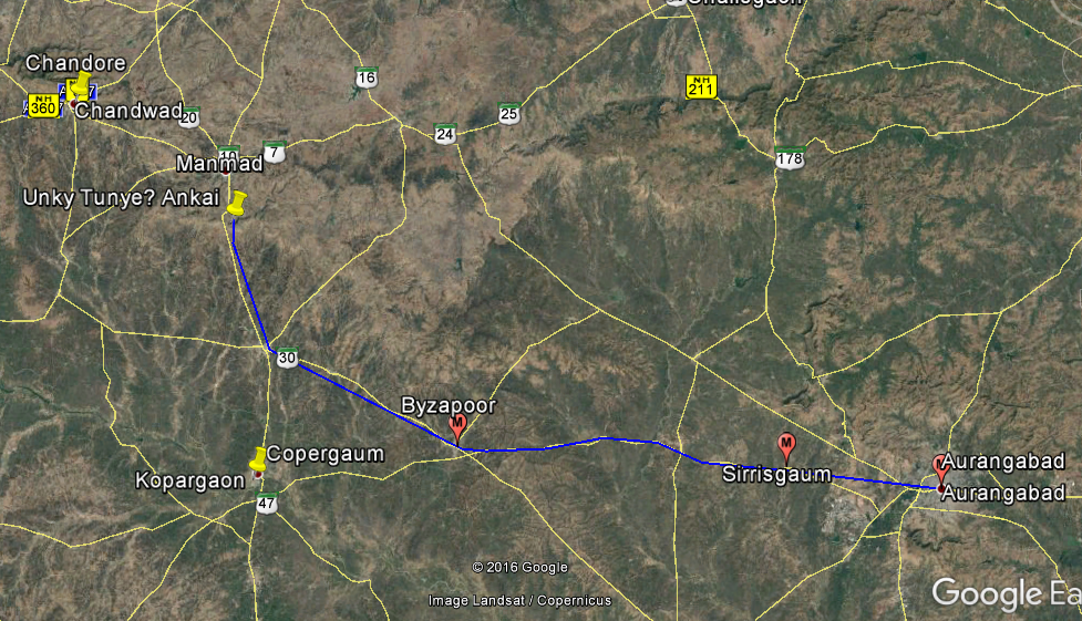
McDowell only had about 1000 firelocks in total in his column, when he had left Sirrisgaum [4] near Aurungabad [5]  on the 30th of March 1818.

His force marched first to the west to Byzapoor [6] arriving on the 2nd of April, before turning towards the north towards its first target, Unkye Killa [7] which is a table-mountain overlooking an important pass about 70 miles from Aurungabad. The fort contained a small garrison, and Lt Col McDowell summoned it, as he approached the Pettah [8]  at the fort of the hill, to form his camp.


Figure 2: Google Earth Image marked to show the route taken by McDowell's column

Lieutenant Edward Lake describes the type of fort that McDowell's forces was about to attack.

“The reader must imagine a series of hills, rising very abruptly from 600 to 1100 feet above General the plain, and only connected with each other, and with the range of which they form part, by very low and narrow necks of land; and he must further imagine occasional bluff rocks, perfectly perpendicular, and varying in height from 80 to 100 feet, to rise from the summit of these hills. The range is evidently primitive, and the rocks which rise from them in this manner, basaltic, being so beautifully and regularly scarped, as to assume the appearance of having been formed by the chisel: and the number of them scattered throughout this range, which is much greater than could be required for the defence of the country, is the only fact, which makes the supposition of their having been formed by art incredible; for the excavation of the ditches at Dowlatabad, out of the same species of granite rock, is a proof of what difficulties the perseverance of the Natives of India is capable of surmounting. Those hills, which contain water on their summit, have been fortified by the Natives, in periods of the most remote antiquity, for there is no record of their first occupation; and the space contained within the rocky scarp before described, which often assumes a very fantastic form, such as only could have been traced by nature, constitutes the interior of the Fort. There is seldom any work raised on them, or indeed any thing done, farther than to cut flights of steps out of the solid rock, and to construct a number of gateways over them; and great ingenuity has been exerted to render these as intricate as possible. Nothing is necessary, but a determined Garrison to render such positions perfectly impregnable. Fortunately for us, this latter requisite was wanting, Unkye and Unkye Tunkye set an example, which was surrenders generally followed, of surrendering without opposition, the Killedar being intimidated by the determined language held out to him.” [9]


Figure 3: Aerial View of Unkye, part of the Inyadree Range.

“He arrived, on the 2d of April, at Byzapoor, on his route towards Unkye, a hill-fort on the summit of the Khandesh Ghats. It contained a small garrison, and commanded one of the principal passes descending into the low country. On this account it was considered of peculiar importance; and Lieutenant-colonel Mac Dowell summoned it, as he approached the pettah at the foot of the hill, to form his encampment. Some attempts at evasion from the garrison were met by a display of impatient determination; and the British troops proceeded to occupy the place on one side, as it was evacuated on the other. This proof of the impression which prevailed in the country, was highly satisfactory. Filled as it was with hill-forts, an opposition from all, however trifling, would have required larger means than those by which it could be met. The minds of the inhabitants also would have remained in a state of suspense, the prevention of which was very desirable. A party of forty Native infantry, under a European officer, was left in the place, wherein were found fourteen pieces of ordnance, with a large store of ammunition, and some treasure. The detachment halted till the 7th, and, on the three following days, marched to Chandoor, where it encamped on the 10th.” [10]

Figure 4:Unke or Ankai Killa. 

Amongst the 14 captured guns, were two 18 pounders, that were unexpectedly to become of great importance to the success of the siege at Malleygaum.


[1] There were ten companies in a battalion at this period, of which two were called the Flank Companies.  The right-hand company was the Grenadier Company traditionally composed of the tallest men, and who had originally been equipped with grenades, for use in sieges, when first formed in the late 17th Century. By 1818, grenades were rarely, if ever issued.  The left-hand company were the Light Company, and their purpose was to skirmish ahead of the line, adopting the tactics originated by the Croats, and taken up by the French Voltigeurs and then the British Army.  Frequently during the Mahratta War these two Flank Companies were detached for special purposes, and sometimes joined by other similar companies to form elite forces.  This often had a detrimental effect on the unit as a whole, as many potential junior leaders and potential future NCO’s were deployed in these companies, who borne the brunt of the assaults and casualties.
[2] Operations of the British Army in India During the Mahratta War of 1817, 1818 & 1819, by Lt. Colonel Valentine Blacker.  Page 317, 318.
[3] Journals of the Sieges of the Madras Army, in the Years 1817, 1818, and 1819 ... By Edward John Lake, pages 87 & 88. At full strength, a battalion had ten companies, each of approximately 80 to 100 men.  With 19 Companies and only 1000 firelocks, it can be seen that these companies in McDowell's force can only have comprised of between 40 to 50 men each.
[4] Sindhi Sirasgaon, 19°54'8.83"N
[5] Aurungabad 19°52'37.00"N 75°20'34.35"E
[6] Vaijapur, 19°55'31.48"N 74°43'52.64"E
[7] Unkye, also Unky Tunke, known today as Ankai or Ankai Killa. 20°11'13.24"N 74°26'55.95"E
[8] Pettah, town or village.
[9] Lake page 90.

[10] Blacker page 318.
[11] Malegaon in modern Indian spelling, 20°32'43.60"N 74°31'48.33"E.

Sunday, 10 April 2011

Captain's Carpenter column moves inland, 1783


Figure 1. Exterior of Mirjan Fort.

The forces from Bombay, were quickly reinforced by a brigade brought up from Ponnani on the Malabar Coast where they had narrowly escaped defeat by Tipu Sultan's forces, after a disastrous expedition to Palghat.

Carpenter calculated that  

"the troops already assembled, under Gen. Matthews, I may, I think, venture to state, that the whole amount of force employed on this occasion, in the invasion of Kanara, did not exceed, at the utmost, 5,800 men; of whom scarcely 1,200 were European soldiers." [1]

General Matthews then determined to attack Mirjan Fort which lay up river along the route that would have to be taken to Compta (or Kumta as it is currently known.) and on to Onore.


Figure 2. Map showing the location of Mirjan Fort,
which threatened the flank of the General's army should it wish
to march to Onore which was situated south of Kumta,
which lay on the route the troops would have to take. 
[Please click on image for larger version.]

The attack on Mirjan started off rather inauspiciously for the East India Company force, however it was quickly realised that the garrison in the fort at Mirjan was not able or willing to put up any significant resistance.

"The arrival of this powerful addition to our force, seems to have determined the General to employ a part of the troops in an immediate attack on Merjee, which looked so invitingly down the river, at the distance of about four or five miles. The division destined for this under Col. Mc'Leod, was accordingly embarked on the river; Lieut. Ross, with whom I became now for the first time acquainted, and myself, with a detachment from the second batt. being ordered on dutv with this force.

We had, however, scarcely entered our boats, when having, for some reason or other, abandoned this design for the present, the General countermanded his orders, and we re-landed.

It is, however, to be acknowledged, that in this change of plan, Gen. Matthews acted with the soundest discretion; since it is sufficiently obvious that by a waste of time, which might have been incurred in attacking a place of such minor importance, the paramount object of the expedition would have been exposed to the hazard of defeat. It is probable that he therefore determined to establish a more centrical, and more eligible basis for his operations, by the reduction of Onore.

Not many nights preceeding, a body of the enemy supposed to belong to the garrison of that place, had made their appearance in the cocoa-nut tope or grove, immediately under the fortified post, at Compta; which I have already mentioned to have been occupied by Capt. Lampard and his corps of grenadiers. With a caution which exposed him to ridicule, that officer, instead of attacking these undisciplined irregulars, chose to cram his whole batt. about four hundred strong, into a work where there was hardly standing room for the men. The enemy deriving courage from this unusual proof of deference, became, as was to be expected, more daring and insolent; although they immediately withdrew on the appearance of the reinforcement, which was hastening to the relief of the post."


Figure 3. Compta or Kumpta today. 
[Please click on image for larger version.][2]

While it is not possible to be certain where Captain Lampard and his grenadiers had built their fortified post. However Google Earth shows that today Kumpta stands on top of a kidney shaped ridge, some 20 to 25 metres higher than the surrounding fields and plantations. It is very probable that this ridge was the scene of the post and Lampard's humiliation.


Figure 4. Kumta today from Google Earth showing the
kidney shaped ridge that was probably the site
of Captain Lampard's post.
[Please click on image for larger version.]

"Whether this circumstance might not have had some influence in drawing the attention of the General more immediately to that quarter, I cannot pretend to say. But the whole united force was shortly afterwards in full march for Onore; Capt. Carpenter's batt. the old second, to which I was attached, or the greater part of it, being left to protect the stores and other equipments, that remained at Rajamandroog."
[3]

General Matthew's main force moved off to Onore (known today as Honavar.), approximately 15 miles to the south, where he and his force set about besieging the town. Captain Carpenter's force was set the task of acting as a covering force, moving towards the west and the foothills of the ghats.

"To our unfeigned satisfaction, our confinement at Rajamandroog was now to terminate. Our commandant having received orders, from head quarters, to proceed with his batt. into the districts within land of Onore to the eastward; for the purpose of repelling any attempt that might be made by the enemy in that direction. We marched accordingly in the direction indicated to us; our corps becoming thus a moving column of observation; acting about sixteen or eighteen miles to the eastward of Onore, and in the direct road as we afterwards found to the Bilghy gauht."

The position this column took cannot be determined exactly, but it is very likely that it was on the line of the modern road from Kumta heading inland towards Siddapura. The road traverses the Bilgi Ghat which rises to about 540 metres in about 2 miles as the Crow flies, although many more by actual twists and turns of the road.


Figure 5. Google Earth Image showing the location of the
Bilgie Ghat. It is probable that Carpenter's force was
stationed in the plain at the toe of the Ghat.

"I am disposed to think, that the corps with Capt. Carpenter at this period, after deducting the men detached, could not have mustered more than three hundred firelocks; one-half of which, however, were veteran grenadiers, inured to service.

To these latter, under Lieuts. Hodges and Weldon, I was now attached. The officers present were—Capt. Carpenter, Lieuts. Hodges, Weldon, Fyfe and Lawrence, Ensigns Morris, Lonsdale, and myself. Lieut. Ross must have been left in command at Rajamandroog."

As so often was the case with 18th Century armies, the column had little or no logistical support, and was expected to forage for it's own rations.  

Lieutenant's Weldon and Price troops were engaged in plundering stocks of rice from one unfortunate village when they came under attack. It is not clear if the attackers were infuriated villagers, or part of a relief force heading towards Onore in support of that towns resistance to East India Company attack. 

"Be this as it may, Lieut.Weldon and myself, with part of the grenadiers, were one day on the advanced guard, in front of an obscure hamlet, called Moordnulla, no longer perhaps in existence; and as we held the commissariat in our own hands, the sepoys were engaged in thrashing rice from the straw, which lay stacked about the villages; being at the time the only source from which we derived our subsistence. There was in front, a rice ground, about a hundred and fifty or two hundred yards over; skirted on the other side by a pretty thick wood of forest trees; and we had on our left, a shallow and transparent river, running over a bed of rock and gravel; and, I am inclined to think, the same river that runs by the fort of Merjee to Rajamandroog."


Figure 6. A modern photo taken by trekker's showing
the river near Kumta, with the ghats in the background.
Although it is impossible to be sure if it is the same 
location described, it gives a very good idea of the
type of territory the column was operating in.

"We had a small advanced party in the outskirts of the wood in our front; and it might have been about one or two in the afternoon, when some musket shot from the wood rendered it necessary that our sepoys should relinquish their employment of threshing, and betake themselves to their arms. In the meantime, I was sent forward by Lieut. Weldon, to bring off our party from the wood. While I was calling in the sentries, several shot were fired at us; and the sepoy orderly who attended me, received a dangerous wound between the thighs, which lamed him for life. I was observing their movements of the few matchlock men that made their appearance squatting among the trees, when a shot struck one of the trees by which I was standing; and a splinter grazed the corner of my eye; without, however, any great injury. I thought it, nevertheless, rather a narrow escape—and I now withdrew the party, and regained the advanced guard, which stood to their arms coolly, awaiting the attack. As the enemy gave no further indication of their presence, they must have immediately retired. And this was probably nothing more than what, in magniloquent terms, might be called a reconnaissance, to discover our force and position.

With that decision which marked his character, Capt. Carpenter, at the head of the main body of our diminutive force, immediately advanced to our support; and as if to demonstrate our readiness to accept the challenge, we all together entered the wood in our front: and having pushed through to the opposite side and some distance beyond, without discovering any vestige of the enemy, we took up our ground for the day."[4]

The small column now decided to advance up the ghats. This must have been a daunting task as they faced a steep climb in the dark up a twisting mountain path, that they had never seen or marched up before. The path would be lined on both sides with dense forest. Today the area is very popular with trekkers and wildlife tourists.

"At our evening parade of the same day, Lieuts. Hodges and Weldon received orders to march with both companies of grenadiers, immediately after night-fall, for the purpose of attacking the enemy— now known to have taken post in some strength, in the Bilghy gauht (or ghat—or pass of the mountains) at the distance of about twelve or fourteen miles. Immediately after dusk, accordingly, we set off; and having continued our march during the greater part of the night, about three in the morning, or at all events some time before day-break, we began to ascend the pass—not without considerable difficulty, in preserving the connection of our files in the darkness, and through the ruggedness of the road.


At last, without meeting with any other obstacle, we came to a gateway defended by a tower, with guns on each flank; which we immediately assailed. Lieut. Weldon being lifted up by myself into one of the embrasures, while I pushed myself round the flank and came upon the rear ;—the enemy making off with great precipitation. Seizing a Frenchman, who had been posted here to manage the guns, I held him up in my arms to remove the gate fastenings, which were otherwise above our reach; and the gate being thus thrown open, the sepoys entered without difficulty. We now hastened forwards; and at a short distance further up the pass, came upon a second gateway, fortified in the same manner with the first. This was also immediately attacked and carried, after a very slight resistance."


Figure 7.  The head of the Bilgi Ghat. Even today, and without a tower
commanded by a solitary Frenchman in residence, it is a stiff climb

"On this occasion, having warded off the push of a spear from under the eaves, which had nearly taken my eye, I ascended the tiled roof of the gateway; and the ground rising abruptly in the rear, I jumped down, as it happened, without injury.

Day was now breaking, and we continued to advance to a considerable distance, perhaps more than a mile, beyond the summit of the pass; until we came to the enemy's bazaar, which we found abundantly furnished with every thing we could desire for the supply of our brave and faithful sepoys. All this was accomplished, as far as I am able to recollect, without a single casualty; which, considering how strongly fortified and armed these gateways were found to be, could not have been the case, unless the enemy had been completely panic stricken."

Following the fall of Onore, General Matthews had marched inland to Bednur using a route that ran to the south of the Bilgie Ghat route. His success in marching inland may have diverted attention away from the route Captain Carpenter's force was taking. Unfortunately Matthews was over stretching himself and disaster would follow.

Meanwhile Captain Carpenter's detachment found itself in what sounds to have been a very pleasant and hitherto untouched settlement. As so often in war, the arrival of troops resulted in a disaster for the inhabitants, who after a brief resistance, took to the nearby hills, forced to look on in horror as their town was ransacked for food and valuables.

"In the course of the two following days, Capt. Carpenter joined with the remainder of the detachment; and we had by this time learnt, that the town of Bilghy, the capital of the district, lay at the distance of about twelve or fourteen miles to the eastward of the pass, of which we had so fortunately obtained possession. On the night of the third, or at latest of the fourth day, after such possession, the whole detachment was on the march to attack the town. We encountered neither obstacle nor interruption until a little before day-light; when a small guard at a sort of barrier gate at the entrance of the place, discharged their matchlocks at us; but immediately making off, left us an unmolested passage.

When day-light came, the town being completely evacuated by the inhabitants, we took possession of the palace of the Rajah; a spacious mansion at the eastern extremity of the long street, of which the town of Bilghy is principally composed; and we found it stored to profusion, with the richest stuffs, shawls, sauries, and other splendid articles of dress; which, at a proper market, might have been disposed of at considerable value. We afterwards learned, to our regret, that all this was the property of the Rajah, said to be favourably disposed towards the British government. Of all, however, we had, without ceremony, taken possession; making on the spot a fair and equitable distribution of the property. There were, however, other articles of considerable value, which we could not so conveniently dispose of; in particular, an extensive assortment of brass and copper ware of every variety, to the value of thirty or forty thousand rupees, which we were constrained to leave untouched.

It may be needless to observe that our operations required despatch, as the enemy must have been in superior force close at hand; and there was full in our view to the eastward, at the distance of not more than eight or nine miles, a respectable looking hill fort, to which our information assigned the name of Goopty. Indeed we must reasonably have expected, considering the paucity of our numbers, that our retreat to the gauht would not be accomplished without molestation.

Having therefore passed the day and the ensuing night, in, and about, the palace of Bilghy, we were assembled about four in the morning round a blazing fire, in the square of the palace; when a jassous or courier, entered, and delivered a note into Capt. Carpenter's hand. The note was from Gen. Matthews himself; announcing the triumphant intelligence, that he was in possession of the ancient and opulent metropolis of Bednour."[5]

The enthusiasm with which this most welcome intelligence was hailed, may be easily conceived— nor shall I ever forget the joy, amounting almost to extacy, with which the sepoys passed to each other the triumphant word "Nuggar lear—Nuggar is fallen."* This gratifying information must then have been received by us about the 31st January, 1783; as Gen. Matthews is known, from his own letters, to have entered Bednour, at the invitation of Ayauz Saheb (usually called Hyat Saheb) on the 29th of that month. The General's note conveyed at the same time an order, that our small force should proceed immediately to the northward, for the reduction of the enemy's forts and districts, north of the river of Merjee. The resolution to withdraw from our present position, which had been taken prior to this information, was thus confirmed or enforced, by the instructions of our Commander-in-Chief.


Figure 8. Bilgie Village.

You get the sense that David Price and the other members of the column found a rather special village at Bilghie, and one that was different to the many others they had visited in their campaigns. Sadly they were like to pillage the village like many other generations of soldiers before and since them.

"I have perfect recollection of the singular cleanness exhibited in every part of the very pleasing little town of Bilghy. The small verandah, in front of every house, was the very pattern of neatness and purity; and I do not bear in mind the image of any place that, in this respect, I can venture to compare with Bilghy as it then stood; unless it be the neat and well ordered weaving town of Gohkauk, below the fall of the river Gutpoorba. It was, however, a complete solitude: for, during the day and night which we remained there, we did not see a single living being, ourselves excepted, in the shape of an inhabitant."

The poor inhabitants watching on from the nearby hills, must have been very pleased to see them leaving for the coast.

It is not possible from the Google Earth images to readily identify the Raja's Palace. Has anybody ever visited Bilgie?

If you live in the area, I would be fascinated to see pictures of the village, and especially any of the older houses. Do they still have verandas?

[1] David Price. Memoirs of the early life and service of a field officer, page 68.
[2] Photo taken by Natasha Chanda Acharga, posted on the IndiaMike website. 
[3] David Price. Memoirs of the early life...
[4] David Price. Memoirs of the early life...
[5] David Price. Memoirs of the early life.page 76.

Captain's Carpenter and his operations around Rajahmundroog, 1783


Figure 1. Mouth of River Aghanashini near Fort Rajahmundroog.
This river used to be called the Merjee or Mijan River by the EIC. Photo courtesy of Shoba.

Most people reading the history of the British involvement in India read about the events that occurred during the 19th Century, the Mutiny, the Sikh Wars or the North West Frontier.

With hundreds, if not thousands of books written about this period, and with these wars ending in most cases in British victories, it leaves the majority of readers with the impression that the development of the Empire was a forgone conclusion, and that all the action in India had taken place during these major campaigns.

This concentration on the 19th Century in India masks a far more fascinating stories. These come from the far less well known campaigns fought and often lost across the Deccan and Southern India during the 18th Century.

In the last couple of years with the huge increase in the availability of digital copies of original accounts thanks to the huge effort that Google has made to scan in these otherwise inaccessible books, it is becoming possible to piece together the fascinating and other otherwise virtually unknown stories of some of these campaigns.

In many of these accounts there are absolutely fascinating stories about minor or subsidiary campaigns fought in support of the major campaigns. With all of the campaigns run on a shoe string, by under resourced forces, these "second or third fronts" were often undertaken by a mere handful of European's and locally recruited Sepoys, who were taking on substantial Indian states like Mysore, with large armies that were often technically at least as well equipped as the East India Company was itself.

The following is the story of Captain Carpenter's campaign fought in 1783 between the modern towns of Karwar and Honavar on the west coast of India.


Figure 2. Google Earth Image showing the general location of Rajahmundroog and the operations undertaken by Captn. Carpenter's Detachment. Please click on this image for a larger version.

In order to try to divert pressure away from the East India Company's settlements and forces on the Coromandel Coast, which were under sustained attack by Hyder Ali and Tipu, it had been decided to send a force from Bombay to land in Karnaka at Rajahmundroog, called today Kagal Kote, north of the town of Honavar.

Hyder Ali had died in December 1782, but Tippoo Sahib as he was then known by the British had already shown that he was a formidable opponent in his attack on Ponnani.

The purpose of the expedition was set out in the following orders sent to Captain Carpenter by General Mathews.

" To Captain Carpenter.
" Sir,—It is necessary that an active, although small party, should remain in the field, and I have thought of you to command it. You will therefore proceed to Chundoor or Comptah, and collect your partizan force. It will at first consist of two iron three-pounders, drawn by bullocks, and the ammunition carried by men. And whatever men of the European artillery and lascars as can be drawn from Rajahmundroog and Onore, and as many sepoys as can be spared from each place, that is, from the immediate service and security of both garrisons. If you get 15 Europeans, and 150 sepoys, it will be reckoned a small army. The object is to protect the country from plunder and conflagration, and by seizing with spirit and judgment every opportunity of attacking the enemy, you may drive them from the frontiers of this district. It will be a fortunate circumstance if you can approach either the fort of Bilghie or Gurripah pass, as it may serve to keep the enemy at a distance, and alarm them for fear that you should really ascend the hills. The garrison of Mirjee also deserves your attention, and you should endeavour to keep them on the north side of the river. Being lightly equipped, and without tents or baggage, your movements may be as rapid as your sense may render them judicious. In short, all the country between the rivers of Mirjee and Onore, are under your protection ; and Capt. Torriano, who commands the garrison of Onore, has orders to supply you with every thing you may want, and to send all recovered officers and men, whether European or Native, to join you. You will strictly observe to keep this one material point constantly in view, which is, the safety of Onore, on account of our stores, provisions, and many etceteras: Capt. Torriano has orders to detain no more sepoys than the necessary guards. When we begin to act to the southward, the enemy may draw off part of their force ; then will be your time to make an impression, and I have hopes of hearing that the fort of Bilghie will, in a fortnight or three weeks, be in your possession. Capt. Torriano will send 2 three-pounders, and 2 artillery-men, with a few Europeans and what sepoys can be spared. You will keep up a constant correspondence with Capt. Torriano, who will occasionally acquaint me of your motions. Your command will be separate from his, unless he finds it necessary to call your party into Onore, for its apparent security, in which case only, you are to act under his orders. I wish you health and success.


(Signed) "r.mathews.
" Onore, 12th Jan. 1783."

It is very hard to understand how it was thought that a force of 15 European's and 150 Sepoys were going to be able to successfully take on the inhabitants of a substantial province well equipped, defended by large and well built forts.

This small force seems to have been intended act in a similar way to the Chindit columns sent into Burma in 1944, operating behind any force from Mysore sent to attack the larger landings at Onore or Mangalore.

One of the best accounts of the expedition comes from David Price's account which was published in 1834.

David Price was a young Ensign who had only landed in India during the previous year. He had however already taken part in the sieges of Negapatam and Trincomalee.

"On the eve of embarkation on a service of such perilous importance, I shall endeavour to bring to mind the nature and amount of that force which was thus about to be employed. There must have been a considerable detachment of artillery, although I have no recollection of the number, under the command of Capts. Toriano and Jackson, with, I think, Lieuts. Jacob Thompson and West; a corps of European infantry, of about four hundred strong, under- Col. Jackson; the basis of two grenadier batts. under Capts. Lampard and Dunn; and the first batt. of sepoys, under Capt. Edward Nugent. To these must be added sundry details, destined to join' the several native batts. already on the coast. There were, moreover, proceeding to the same destination from Surat and Broach, the third, fifth, and fifteenth batts. under Capts. Richardson, Eames, and Maccullock; which would add to the force already mentioned, probably two thousand rank and file; with some very valuable and experienced officers ; and altogether making a total of about three thousand eight hundred rank and file, of every description. The merit of Lieut. Oakes was already so highly appreciated, that he had allotted to him the command of a separate and independent corps. But with the exception of Lieut. now Gen. Blachford, I have not been able to bring to my recollection the names of any other officers of engineers, who accompanied the expedition.

Of the precise date of our departure from Bombay on this occasion, I have preserved no memorandum; but as far as I am now able to judge, it must have been early in the month of December, 1782—just fifty-two years ago, calculating to the year 1834. There was not among the whole of us, I sincerely believe, a single individual who did not entertain the brightest hopes of success ; and our short voyage of three or four days, for it required no more to bring us to the scene of action, passed in cheerful and unalloyed enjoyment. Ensigns Morris, Lonsdale, and myself, with the detail for the second batt. were embarked on board of a Surat battela, a quarter-deck vessel, peculiar to the north west of India ; which may accommodate from an hundred to one hundred and fifty men."
[1]

Captain Carpenter's force was part of a larger force that was going to make landings at Honavar or Onore as it was known at the time. The force was carried down the coast by the ships of the Bombay Marine commanded by Commodore Emptage in his 28 gun flag ship Bombay.[2]

The area where the landings were made are surprisingly unchanged since these events took place in 1783, and it is quite easy to follow the course of the actual events on the ground, on maps and in Google Earth.

The landings were initially going to be made at the mouth of the Mergee or Aghanashini River at the Tadri Creek on the north bank near the modern town of Gokarna, with the intention that the force should attack and destroy a ship building yard at Tadri,where allies of Tipu were building a 50 gun ship, with the potential to out gun most East India Company vessels.

However at the last minute the force went for Rajahmundroog on the south bank. There are several potential landing beaches shown on Figure 3 below. It seems that Price's boat went straight for the smallest beach directly under the walls of the fort, whilst others landed on the slightly larger beach at 3.

"On our arrival at a short distance to the northward of the river Merjee, a small sandy bight or cove was pointed out to us, as the spot on which we were likely to land. This would have brought us immediately on the rear of Tudry, where there was on the stocks, what was called a fifty-gun ship. It was, at all events, a vessel of considerable burden, at a subsequent period, burnt by my friend Ross. We had however, scarcely time to deliberate, when we were hailed to make for the beach, south of the river, just under the straggling fort of Rajamundroog. "We accordingly made for the shore, and ran the battela [3] aground. For some minutes we were rather unpleasantly exposed to the guns of the fort—and several shot passed over us. A party of our troops was approaching at the same time from the land side, to attack the gateway, which looked to the east: and we hastened also in the direction of the gateway, from whence a pretty sharp firing of musketry was kept up on the party under Lieut. Stewart, the major of brigade. The gateway was flanked by two towers with guns; and we were close at hand, when we saw Mr. Stewart lifted up by the sepoys into one of the embrasures ; on which the gateway was immediately thrown open to admit of our entrance.


Figure 3. The landing beach and fort at Rajahmundroog. Please click on image for larger version.

"The garrison, whatever they were composed of, had entirely disappeared, with the exception of one man, a Carnatic matchlock man; who suddenly arose from among the long grass, with a wisp of hay in his mouth, and threw himself at our feet. I cannot but remember this man, who was one of the tallest and stoutest natives I ever saw; and I often met him afterwards, as he became enrolled among our ordnance lascars. The fort contained about twenty iron guns of different calibres."
[4]


Figure 4. Rajahmundroog Fort, showing ruined building sites. Please click on image for larger images.

"The troops were now disembarking in various directions, particularly from the river, which enters the sea immediately below the hill on which the fort is erected; and was of sufficient depth to admit the anchoring of the old Bombay Grab, a ship of twenty guns. They were encamped across the ridge of the hill to the eastward of the fort, looking directly towards Merjee; which, in a declining sun, appeared rather formidable, with its double line of walls and towers, fausse-bray, and ditch. One of the grenadier batts. was detached under Capt. Lampard to occupy the post at Compta, a little hill fort on the beach, about five miles to the southward. A few days afterwards we were joined by the troops from Malabar: consisting of the forty-second, and hundredth, King's regiments, under Cols. Mc'Leod, and Humberstone: the second, eighth, and eleventh batts. of sepoys; with a proportion of artillery, under Capt. Hislop, a very promising officer of that corps, in the King's service. He was killed not long afterwards in the attack of Hyder gauht, on the march to Bednour. Adding these to the troops already assembled, under Gen. Matthews, I may, I think, venture to state, that the whole amount of force employed on this occasion, in the invasion of Kanara, did not exceed, at the utmost, 5,800 men; of whom scarcely 1,200 were European soldiers."[5]

It is possible to locate quite closely the probable site of the camp to the east of the fort, and from there it is clear that Merjee or Mirjan Fort must have appeared very formidable as it showed up in the setting sun, which would have been behind David Price's shoulders. With that red stone set into the green hill it must have been very impressive.

It must also have been frightening to think that you might have to try to climb up its walls in a few days time.


Figure 5. Image showing possible site of camp and the view towards Mijan Fort. Please click on image for larger version of image.


As the following photo clearly shows the fort at Mirjan was a very formidable one, and it was going to require a very substantial attack if it was going to be taken.

Figure 6. Mirjan Fort, looking towards Rajahmundry. [6]

If you live near these forts or have pictures that you have taken of either Rajahmundroog or Mijan Fort, I would love to have a copy of those photos.

If you are able to point me in the direction of other accounts of these actions, I would also love to hear from you, especially if they come from the Indian point of view. From similar projects in Kerala I am aware that there are a surprising large number of oral stories preserved within the communities affected by these events, and they can be extremely accurate.

If you have one of these please contact me.


Figure 7. Mirjan Fort from Google Earth.


In a future blog I will attempt to follow the fortunes of this expedition as it moves inland.

[1] David Price. Memoirs of the early life and service of a field officer, page 65 & 66.
[2] C. R. Low, The History of the Indian Navy, volume 1. page 180.
[3] Battela, a word that seems to come from Portuguese originally, that is applied today to a particular type of double ended rowing boat, but which seems to have been applied in this case to a local type of ship from Surat with a deck at the stern and substantially larger than the modern Portuguese Battela.
[4] David Price. Page 67.
[5] David Price. Page 68.
[6] Photo by Ranjaub see http://www.skyscrapercity.com/showthread.php?t=1035227 This thread has many more photos of this very interesting and impressive fort, that appears to be undergoing a substantial restoration.

Sunday, 13 January 2008

Forts in the Vasai and Konkan Region.


Bassein Fort circa 1817, an engraving by Akermann circa 1820, from a drawing by Captn. James Barton.
Please click on the picture for a larger version.


Hello,

The purpose of this post is to provide a discussion area on the history of a number of forts in the area around Vasai, an area approximately twenty miles to the north of Mumbai.

Why should I, an Englishman be interested in these forts?

Well, it all stems from my great great great grandfather, Captain James Barton. James was an officer in the Bombay Artillery, who served in the area from 1811 until 1827, when he died at Matoonga.

My interest originally stemmed from the fact that I had discovered that twenty one coloured engravings had survived, which had been made from drawings that he had sent to Ackermann in London.

I wanted to see if I could find out where these forts were located. Little did I know quite where this journey would take me.

These drawings are kept in the British Library, along with copies of his other drawings, which can be see on the Collect Britain website at http://www.collectbritain.co.uk/

What is especially poignant, is that this particular drawing probably contains the only image that we have of James himself. We possess a letter dating from the 1870's from his son, retired Major General Charles James Barton, who nearing death, and with a one year old son, realised that this son, would probably also be faced with never being able to remember what his fathers face would look like.

Poor Charles wrote, that thoughout his adult life, that he had been troubled by not knowing what his father had looked like, for he had been an infant when he was left without a father.


James Barton seated with his sketch pad

Charles Barton also served in the Bombay Artillery in much the same area in the 1840's, 1850's, and 1860's.

Unlike his father, as far as we know Charles was not an artists, although his brother was. Charles however embraced the new science of photography. It is not clear whether he took the photos himself, or whether he engaged the services of a professional photographer, but what is clear, is that he collected a series of photographs starting in 1857 at Bulshire in the Persian Gulf, as he returned from taking part in the expedition to Persia.

Along his return journey he appears to have been deliberately visiting and recording the places where his father had served.


Major General Charles J Barton, Bombay Artillery

In attempt to research these events, I first visited the British Library Asia Pacific Collection, but wanting to go beyond the dry words on the page, and wanting like my great great grandfather, to be able to visualise the locations, I started to research the places through the internet.

My starting point was the India Rootsweb, which can be joined by emailing and subscribing to INDIA-request@rootsweb.com

One of the members of that list Arvind Kolhatkar, turned out to come from the Konkan region, and with his help we soon traced many of the locations.

I also widened out the search, and discovered that there is an intrepid group of young Indian's who are increasingly spending their time trekking to these often remote forts, in the Ghats.

Taking my courage in my hands, and to their great surprise, I began to approach these trekkers by email, and they have all been unfailing helpful in return. Kiran Kharade and Ravi Vaidyanathan, have been extremely helpful, and with there very good local knowledge and keen interest, I have been able to piece together a great deal of information on the places my ancestors visited.

My interests have for a lot time extended beyond, just those directly connected with my own family. I have a deep interest in colonial history, which I believe should be called early globalisation.

By learning about the events of what was in many ways a prototype for many of the events in todays complex world.

Central to my research at Bassein as my ancestors, would have called it, or Vasai as it is now called, has been Shridatta Raut.


Shridatta Raut [first on the right] explaining the history of one of these forts,

Shridatta emailed me having seen one of my posts about Bassein. He lives in Vasai and visits the fort every week. He has sent up a group of volunteers dedicated to protecting and preserving the fort.

He was kind enough to go out with copies of the drawings my ancestor had drawn, and to find the locations on the ground.

Each week he has been organising visits for school groups and the general public.


With his volunteers he has removed tonnes of rubbish, and he is working to remove the trees which are growing out of the very walls of the buildings.


The team working out the plan for the following week.


Mapping work in progress.


The scale of the undertaking can be seen from the following aerial photograph.


Vasai Fort

However the quality of the buildings that he and his friends are seeking to protect are such, that I believe he deserves as much support as possible.


Not content with coping with a project of this size, Shridatta Raut has recently started turning his attention to the forts to the north of Vasai, including Mahim and Shirgaon.


Exploring Shigaon Fort

So whether you know Vasai Fort as Vasai, Bassein, Baxay, Baçaim, we would like to hear from you.

We would particularly like to hear from Mahratta or Portuguese people with access to accounts, maps or drawings that can tell us more about these fascinating forts and there history.


Engravings of Chaul [top] and Baçaim [bottom], from a French 17th Century book, courtesy of Gallica.